By James Maina
The month of May marks
the cessation of the “Long Rains” season over most parts of the country except
the Western highlands, parts of central Rift Valley and the Coastal strip. The forecast also indicates reduced rainfall
intensity in most parts of the Country.
The outlook for May 2016
indicates that Mombasa, Mtwapa, Kilifi, Malindi, Msabaha, Lamu, and other parts
of the Coastal strip are likely to receive above normal rainfall. Most areas in
the Western highlands like Kitale, Kakamega, Eldoret, Kericho, Kisumu, and
Kisii are likely to experience near normal rainfall with a tendency to above normal.
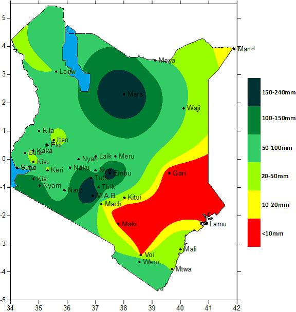 |
| Spatial map of rainfall totals in Kenya for 25th April to 1st May 2016 |
Northwestern Kenya
(Lodwar, Lokichoggio, Lokitaung), Central Rift Valley (Narok, Nakuru,
Nyahururu, Kajiado), Central highlands including Nairobi area (Embu, Nyeri,
Meru, Murang’a, Kiambu, Dagoretti, Wilson, Thika, Kabete) and northern Kenya
(Marsabit, Moyale) are likely to receive near normal rainfall with a tendency
to above normal (enhanced rainfall).
The Northeastern Kenya
(Mandera, Wajir, Garissa) as well as Southeastern Kenya (Machakos, Kangundo,
Makindu, Voi, and Taveta among others) are likely to receive near normal rainfall
tending to below normal (generally depressed rainfall).
The Kenya Meteorological
Department forecast indicates that the seasonal rainfall would continue to June
over the western and coastal regions. It is however likely to cease between the
third and fourth week of May over the central regions including Nairobi, Northwestern
Kenya and southern Rift Valley. Most of Northeastern and Southeastern regions
will experience the cessation during the second to third week of May.
May forecast indicates
good crop performance in the agriculturally high-potential areas of Kitale,
Eldoret, Kakamega, Kericho, Kisii, Nandi Hills as well as the Central region
due to enhanced rainfall. However, the crop performance over most parts of
southeastern Kenya is likely to be poor due to the expected depressed rainfall.
According to the Kenya
Meteorological department, enhanced rainfall in Northwestern Kenya would lead
to improved pastures for livestock. The situation is however likely to
deteriorate in Northeastern Counties where depressed rainfall is forecasted.
The problem of water scarcity for livestock is also likely to arise as time
progresses.
Probability of lightning
strike is high in Western Kenya especially within Kisii and Kakamega counties
while flooding is highly probable along the coastal region, Budalang’i, and
Kano area. Landslides in the prone areas such as Murang’a and Nyeri are still
likely to occur especially during the first half of May. People living in such
areas should be on the lookout to avoid loss of lives.
According to the Kenya
Meteorological department, weather forecasts are unpredictable as the weather
keeps on changing hence it is important to use 24-hour forecasts and regular
updates from the meteorological department.
Regression of sea surface
temperatures (SSTs), SST gradients and the expected evolution of global SST
patterns as well as upper air circulations patterns on Kenyan rainfall helped
in the formulation of the May 2016 rainfall forecast.
No comments:
Post a Comment